

STUDIES

- Details
- Category: Uncategorised
- Published: Tuesday, 03 December 2019 09:47
- Written by Super User
- Hits: 469
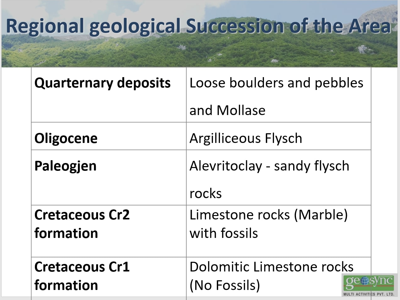
- Rocks of the upper cretaceous limestone's
The oldest deposits on the surface was detected in the area kruja are cretaceous carbonate deposits .
These depositions are characterized by pronounced facial changes. The study of microfacilas shows that in the northeastern part of the area kruja, generally the facial futures are the same and belongs to the not deep fades (internal neritike). While in the southwestern part, in the area of Tomorri ( where are included the structures of Tomori, Kulmakes, Qeshibesht and melesin) facia is transitory with bentosice fauna and plactonice set ( outside neritice).
In area kruja the carbonate depositions generally belong to the upper cretaceous. Thematic studies on cutting of Tomorri, based on the presence orbitolinidae and the face of rudiste and pithonella ova lis, is given a thicknees of about 380m, that can belong to the lower cretaceous. In the Devria and Qebeshisht cutting, in the lower part of the cutting is determined a thickness of about 350m. With orbitolina, hedbergella and pitholina ovalis, evidencing the presence of the lower cretaceous . In the geological map for the lack of mapping, this thickness is included in the upper cretaceous .
These deposits are meet in all carbonate structures found on the surface, starting from Renc Karakiqit structures in the north, in Dajti, Makareshit, letan, tervoll, Tomorr-Kulmak till melesin(Leskovik) in the south.
In the Tomorri subzone these deposits are represented from facie and merges. As noted above in tomorri cutting, the lower part is represented by a bundle dolomites, without fauna, which since is extended down bioklastike limestone with flint of Albanian -Cenomanianit is interpreted as part of lower cretaceous. Massive dolomites occur without stratification, combined with rare dolomite
layer thick. Mainly dolomites are crystalloid, rarely are meet with fragmentary dolomites. Above the
dolomites follow the successive cutting of limestone's biocalacarinite with flint, where have been define :orbitolina,Sellialveola viali, orbitolinopsis capusensis, Cisalveolina fallax, Pinthonella ovalis, Hedbergell. Those testify for an age from Albian up to Turonian. The age of Dolomites package which reaches a thickness of about 380m, results of age before Albiane, but not older than lower cretaceous.
In the biomicritic and micritic limestone's combined with linz and silica concretions, which follow above, along bentosike forms as: miliolidae, Textularidae, Cuneolina, Accordiella conica, Montcharmontia apeninica, Discocyclina schumbergeri, Orbitoides media,Rudistae and Gastropoda where have been define; Globotruncana area, G.gr.lapparenti, G. Ventricosa, heterohelicidae, belonging to area Rossita fornicate- Globotruncanita stuartiformis till Abathomphalus mayaroensis. In Devrija and Qeshibesht cutting, addition to plankton areas are isolated their benthonic equivalents ( areas CsBl till CsB7). In cutting carbonate structure of this southern sub-zone have been revealed a thickness of 200m limestone biomicritic and micritic area, analogous to those of the Ionian, where segregated areas : Rossita fornicate- Globotruncana stuatiformis, Gansserina gansseri and Abathomphalus mayaroensis, dated the Kampanian and maastriktian of upper cretaceous. The above facts show that the sub-district of Tomorri belongs to a transient facie and that is always running south and deeper.
*
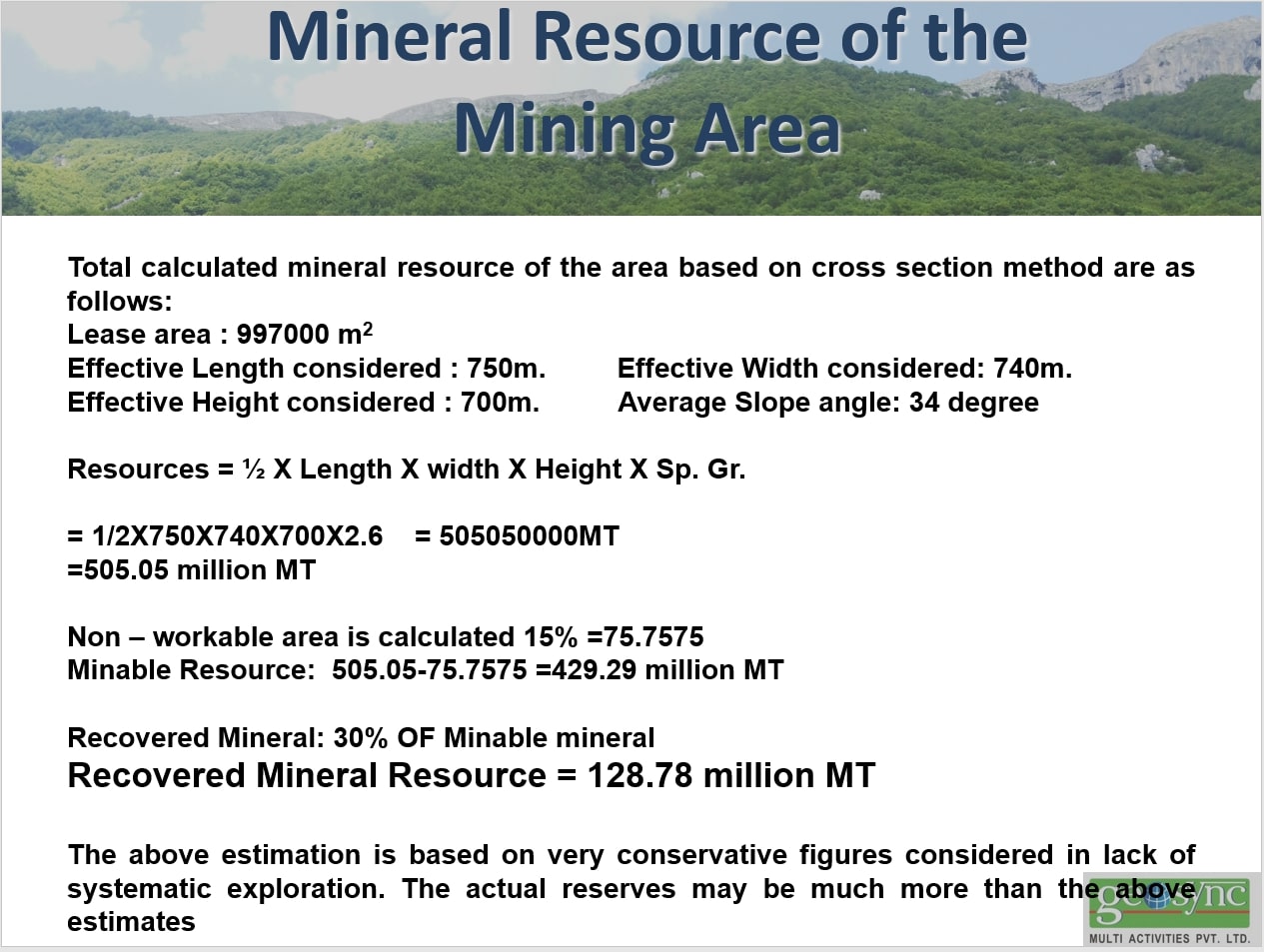
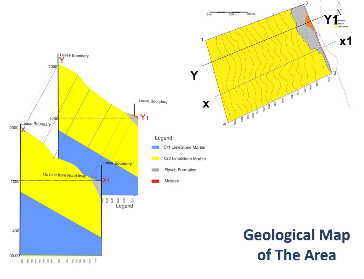
2. Geological Calculated Reserves
*
The approved surface has an extension of 0.997 km2. Distance between the highest quota utilization and the lowest is 750m. C1 category reserves and are calculated as follows :
997000m2 *150m= 747.750.000m3 * 0.7 = 523.423.000m3/3 = 174.475.000m3
The rate of yield of these reserves ranging from 0.25 till to 0.35. Extractable possible reserves are over 43.618.750m3.
Whether the production will be 10.000m3/year, life expectancy of career will be over 4361 year. But a maximum utilization of 25.000m3/year ,life expectancy of career will be over 1744 year .
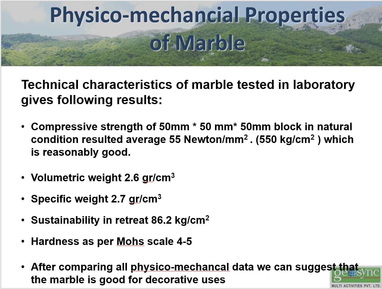
3.Physical and mechanical properties of rocks
Samples taken in the area required for use, were studied by mechanical and physical petrography and geologic .These petrographic and geochemical physical and mechanical data are taken from the legal source of national natural Resources Agency.
Mineral Department with No.302 with project No 2972
These parameters resulting from chemical analysis of samples taken on the ground:
|
CaO |
54.55% |
|
AI203 |
0.23% |
|
Fe203 |
0.11% |
|
MgO |
1.14% |
|
H.K |
43.30% |
|
Si02 |
1.45% |
|
S03 |
0.02% |
|
Insoluble residue |
0.50% |
*
|
Volumetric measures |
2.67 gr/cm3 |
|
|
Specific measures |
2.78 gr/cm3 |
|
|
Resistance to oppression |
500- 700 kg/cm2 |
* |
These parameters resulting from chemical analysis of samples taken on the ground :
*
4.Mineral technical conditions
*
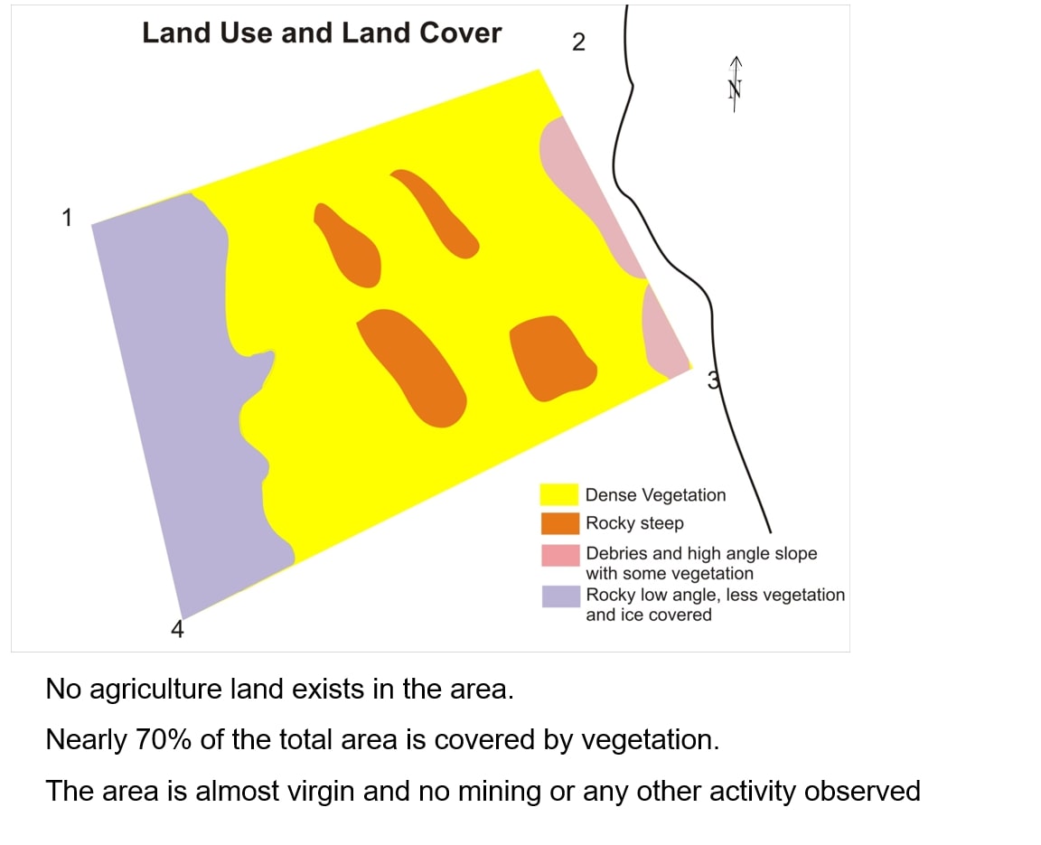
The limestone object for use is located on the surface.
The required area for exploitation has negligible coverage of short vegetation, the surface area is bare limestone, at specific locations has stained high beech vegetation. Since the layers of rock eroded is small discovery will not be made, these wastes will be deposited in the waste disposal site near the subject and objects will be used to pave roads.
The area required for designing has regular rectangular shape.
The higher quotas designed for use will be +1250m and lower quotas for use will be +1150m. The rock formations on which mineral activities will be made, is classified in the first category (Strong rocks), with resistance to oppression 250 bar. They are resistant to corrosion by water or at other actions on them from different atmospheric agents. When they are maasive, their stability in steep slopes is great.
Based on these indicators this subject has good technical minerals conditions.
4.1.Choice of mode of exploitation
The choice of rational exploitation and simultaneously right choice of equipment minerals is done starting from the type of ore, which in our case is the marble limestone, shape of the object and hydro geological conditions.
The field of marbled limestone is located in the surface. Their productive package is naked and in some places partially covered with a layer of vegetable land, with negligible thickness which will be removed to make the discovery of stone and will be deposited at the specified place.
The tranche is made within the technical requirements for its smooth operation and will be within the area.
Field is located in a hilly mountain, which creates conditions more suitable for use within the open sky, and there is no problem to remove the water, after the first phase of exploitation in the final which is projecting calculated for a 25-year term, and estimated to be 1150m to +1250 m.
Exploitation of limestone will be in the open sky with 10m heigh scale.
favorable slope makes it possible to simultaneously use several instances, as the direction from top to bottom, with the added height increasing number of instances in operation, while maintaining the level declination of 70 degrees slope, and that the extinction of 60 degrees career, where the square base is
+1150 m above sea level. Exploitation will be done from the top down, from the horizon +1250 m and will be completed in the horizon +1150 m.
Finally, exploitation will be done with work surface career.
4.2.Utilization system
Systems used in quarry exploitation are:
1. The simplest system utilization without transport
- The utilization system by the use of transport vehicles.
These are the factors taken into account in choosing the system of exploitation:
-
- The way of performing the works of spoiling.
- Loading and transport mode
- Type of means of transport to be used
*
The uploading of the material will be done by the use of excavator with bucket capacity 1m3. Transport of the material will be done by self-unloading vehicles .
Based on the above factors, the system of exploitation that will be used in this career will be the transport vehicles and internal storage in stacks northwest of career. Material that will be released from spoiling work, will be charged on vehicles with side loader, and will be transported to the landfills within the career.
Exploitation will continue from top to bottom.This way allows the works on a regular basis, regarding the level of safety at work, and creates opportunities to work not only on a scale, but in several instances simultaneously .
4.2.1Elements of the system of exploitation
Highest level in career: 10m
Width of working square:25-30m
Width of security squares: 3m
Loading and transport: mechanically
Collapse of mechanized limestone: use of explosive materials
Daily production of stone: 8.41m3lday
The daily production of marble stone blocks: 3.79m3lday
Daily yield in production: 2.43m3lwork day
Labor productivity per day: 2.03m3lwork day Labor productivity per day I total employee's stone blocks: 0.63m3lwork day
labor productivity per day I workers directly stone blocks:0.75m3lwork day
- 4.2.2Order of exploitation
*
Order of exploitation shall be from the top down
4.2.3Utilization direction
Utilization management will generally be from the center toward the southeast border. Even exploitation +1240 m horizon will start at halfTranches short as noted in the opening variant.
The lower horizon as the foregoing will be developed by sloping terrain elevation line 3-5%, according to the same direction exploitation.
Use in the first year will continue +1250 m horizon until the end, and then crossed the horizon +1240 m.As we have argued above, this is the most favorable way of exploiting in the open sky.
5.Attached the approval certificate and topographic map 1:25000 with permission No.1617